We left home late on Thursday night, hoping to get past some of the snow and get an early start at the trail head. We made it as far as Panguich before deciding to stop for the night at 1 am. We slept in the car in a church parking lot.
Day 2, 2/23/07
We left Panguich at 6 AM because I could not stand to try and sleep in the car anymore. It had snowed a little during the night and the barometer was still predicting showers.
We slid off the road between Bryce Canyon and Escalante around 8:30 AM.
 I guess we should have slept a little longer and tried to find somewhere to eat breakfast so the snowplows could clear off the roads.
The tow truck pulled us back onto the road around 10:30 am and we were back on our way. It cost $188. The alignment was damaged on my car and something under the car was knocked loose – we had to listed to it rattle the rest of the trip in the car.
We finally made it to the top of Davis Gulch at 1:30 pm.
The Actual Trip
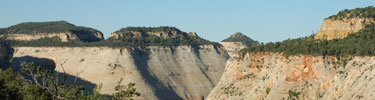
We walked along the top of the gulch for about 2 miles. If you’ve read any accounts of people doing this, they recommend against it. I now totally agree. The up-and-down was extremely tiring and we couldn’t really see into the gulch anyway. With full packs on we didn’t dare get too close to the edge.

We turned west to get out of the up-and-down. By this time, the weather was starting to catch up to us and we decided against trying to camp in the gulch. We had pushed our luck pretty far already and did not want to chance a flash flood. We walked through extreme winds and some light snow. Finally, from the South, we could see a major storm coming and decided to set up camp. We found a relatively sheltered spot on the North side of a large rock and set up the tent in an alcove walled by rock on 3 sides (12 S 0501858, 4125456). We were only exposed to the North. Just as the tent went up, it started to snow and the wind really picked up.
We climbed the rock next to which we had setup camp. It was about 100 feet above camp, and the winds were unbelievably strong. They were gusting at least 30 mph. We scouted around the campsite, walking about 1 more mile in a circle and found some sink holes with water just to the east of camp about 1/3 of a mile away. Circling north and west we found an alcove into which many people had carved their names in the sand stone, dating back to 1944.
K.C and I debated the worth of those scrawls, as it seemed that the older ones were almost historic. I am of the opinion that, although I will never do such a thing, in 50 years it might be interesting to see those names in the middle of the desert.
Dinner was a cold affair because of the gusting and swirling wind. As soon as we were done eating we dove into the tent and sleeping bags to read and snooze away the rest of the day. We were both exhausted from the walk, cold, and the excitement from the morning’s slide off. I could not help worrying about my car and how close we had possibly come to injury or death. I think I was affected mentally more than I had considered until that moment.
Day 3, 2/24/07
I got up around 6:30, climbed our rock, and watched the sun rise. The exhaustion and fatigue from the previous day seemed to melt with the rising of the sun and some communion with deity
 . I contemplated naming our rock “Prayer Rock” but decided on “Sunrise Rock.”
I went down to retrieve my food to eat breakfast and decided to find a spot about ¾ of the way down the rock to eat. After calling to K.C, he came up too and we ate breakfast watching the desert wake up. Thereafter, we called the rock “Breakfast Rock.”

We left camp at 9 AM, angling west. We wandered in a North/west direction and found a heart shaped igneous rock sitting in the middle of a sandy spot. We also found the millstone.

We ended up walking too far north without turning back to the east and had to back track a little in order to find the descent point into the gulch. We built up some rock cairns so that future hikers might find the descent point a little easier than we did. It gets a little hairy in that area and previous rock cairns were gone.
We explored the gulch past Bement arch. The desert is tricky this time of year. When we were in the sun we would start to sweat, but as soon as we entered a shaded spot we’d be chilled to the bone. It was often cold enough that water was frozen in the shaded areas. We located some Anasazi ruins and rock paintings.

Once past Bement arch, the only Anasazi remains are some steps climbing out of the gulch near the narrows. We didn’t make it that far this time though, as we started running out of time. Progress up the gulch is more difficult this year than in previous years. A lot of reeds have grown in the bottom of the gulch and then knocked down by floods, making progress in some areas extremely difficult.
You can see a lot more pictures of the paintings and ruins we found on my flickr page.
As we hiked back, our pace was relaxed and we mis-judged the time it would take to return to camp. We ended up hiking for over an hour in the dark. Luckily, I had a head lamp and we had a half moon lighting the way. In those conditions, we wouldn’t have made it back to camp without the GPS. The desert offers so few landmarks; I can see how easy it would be for someone to become lost.

Dinner that night was pleasant as there was only a slight breeze and the stars were close.
Day 4, 2/25/07
Despite the best of intentions, we slept in a little and missed sunrise. We ate breakfast listening to howling coyotes and then broke camp. We walked east to the sink holes for drinking water for the trip out. All we could find was a small pool that had a thin sheet of ice covering the top. Thank heavens for water purifiers.

The portion of the trip out was relatively uneventful, but we mis-judged the route and ended up walking ¾ of a mile east on the road. We climbed more than we needed to also.
All in all, this was another great trip with some important lessons learned:
- Wait for the snow-plows to clear the road when you’re in a Civic with bald tires
- Don’t try to walk along the edge of Davis Gulch
- Walk almost straight South to the car, avoiding all the up and down
- Park west of the top of the gulch, at least ¾ of mile, to avoid extra climbing on the way out
Coordinates of interest:
Milstone:
Campsite:
Descent: